Tuesday, July 31, 2007

Lost Lake: There's a reason it's Lost

So today the morning started off foggy but less wet, and we were sure that like yesterday, the fog would burn off and we would have a nice day, so we decided to do the Lost Lake Traverse. Given we only had one car, we decided the best option was to attempt to hitchhike to the far end trailhead and then hike back to our car. So after 20 minutes by the roadside without any success, we decided to make it an out-and-back instead.

We made our way up the trail, and were pleasantly suprised how gradual and consistent the grade was, allowing us to travel quickly (we seem to prefer rough steep trails, so this was a pleasant change). This trail had be recommended to us by several people as one of the best hikes in the area. But as we ascended into the fog, we knew we were not seeing it at its finest.

The initial section was through coastal rainforest. We ascended past treeline, and were in open tundra which was a sea of wildflowers. We hiked along a series of ridges, and imagined the views of the surrounding landscape must have been fantastic. Unfortunately for us, visibility was quite poor. The few hikers we met seemed like ghostly apparitions as they materialized from the fog. We eventually arrived at Lost Lake, and thought it seemed aptly named, since we could only see 30m from shore.

We returned back down the same trail, running parts of it, came back to town, and worked on catching up on our blog.

Monday, July 30, 2007

It's an Exit

Today we hiked up the Harding Icefield overlook, besides the Exit Glacier. The morning started foggy and drizzly, and we dressed accordingly. As we progressed up the trail, the sky cleared and the clouds parted, and we were grossly overdressed with not a lot of options to strip down. Mercifully, it was somewhat cooler at higher elevations.

On the way up, something with the scene wasn't quite right, but I couldn't quite figure it out. Then looking at the glacier slithering its way down the lush valley, the oddity suddenly struck me: I've never looked down a green valley to see blue ice. In the Rockies, the toe of the glacier is almost always at or above treeline (at least the ones I've seen).... can anyone out there think of an exception? Well here, in coastal Alaska, even though treeline is at about 900m, the toe of exit glacier is at about 100m.

As we topped out on the trail, the immensity of the Harding Icefield became apparent. The distant Nunataks that defined the limits of what we could see were nearby blips on my topo map.... the bulk of the icefield still lay beyond. I'm sure a flightseeing tour would be needed to get a sense of scale of this place. My mind started racing with possibilities for yet another novel location for our annual winter-camping slogfest: doing some sort of traverse of this icefield would be breathtaking.

Sunday, July 29, 2007

Seward in the Sun

Seward is named after William H. Seward, who lobbied to have Alaska bought from the Russians. It is not pronounced, as we initially thought 'Seaward', as in 'towards the sea, but rather 'sewered', as in 'past tense of of the verb 'to sewer''. Despite the pronounciation, the place is very picturesque... similar to Valdez... we're still trying to decide which we like more.

Today we planned on Hiking Mt. Marathon and going to see Exit Glacier, but Carole was not feeling 100%, so we decided to have a down day and hung out in the sun and read. This is quite a pretty place, with the sea, mountains, and glaciers all within view.

Saturday, July 28, 2007

Adieu to Anchorage

Today we bid farewell to Jenny and Travis and made our way around Turnaround Arm and over towards Hope. The Seward Highway is extremely beautiful, winding its way around Turnaround Arm and snaking its way through the Chugach mountains in the Kenai Peninsula.

En Route, we stopped at the Alaska Widerness Conservation Centre, where they provide home for orphaned or injured wildlife. One never likes to see animals behind bars, much less finance it, but this seemed like a worthwhile cause. If the sight of two adolescent grizzlies wrestling in the water three feet from you doesn't make your heart melt, you are truly jaded.

From there, we continued on to Hope.... however, the campground there was full, as it's the weekend. So we decided to continue on to Seward, arriving quite late, setting up camp and going to bed.

Friday, July 27, 2007

Anchorage Continued...

The past couple days in Anchorage have been wonderful. We found times in the morning to go for a couple runs. Yesterday around an old airstrip, and today, at Jenny and Travis' insistence, we opted for a 15 minute drive to Chugach State Park. It was incredible! Carole ran the powerline trail, which is heads up a very pictureque valley. I did a viewpoint loop which gave some great vistas of Anchorage, and finished up on the powerline.

Afternoons were spent getting replenishing supplies, including an oil change for our Bluebaru.

Wednesday, July 25, 2007

Anchored in Anchorage

Today we left Denali and drove to Anchorage. We had some final parting views of Mt. McKinley along the Parks Highway, which took us south to Anchorange. Even though the population is only 300k, it was quite overwhelming and stressful to have to drive in traffic again after a month of peaceful highways and small towns. Coming back to Calgary will be a real shock, we're sure.

We stayed at Jenny and Travis' (who I met skiing a few years before). Jenny was away, but Travis, Carole and I went out for some fabulous gourmet pizza at the Moose's Tooth, a local pizza place/brew pub.

Tuesday, July 24, 2007

Denali: Thorofare Pass

After yesterday's epic eight hour bus tour, Carole decided to forego a repeat performance. I was not so clever, opting instead to join a free guided hike offered the by park service. Yet another four hours brought me back to Fish Creek, where we met the ranger who led the hike. This morning however, was a cloudless blue sky day, and we had stellar views of Mt. McKinley driving in and during our hike. We gained several hundred metres and had incredible views of the sweeping valley below, as well as 'The Great One'. Mountains like McKinley are dramatic examples of why they have always been considered the home of the gods. The huge icy monolith in stark contrast to the grey/brown/green landscape seems quite ethereal, a place that's pure, pristine and distinct from where humans live.

Meanwhile, back at the ranch, Carole went on an interpretive 2 hour hike of Horseshoe Lake, renowned for being frequented by moose. However, the moose were obviously hiding from her. Afterwards, she went to the Dog Shelters, where they train and care for the Alaskan Huskies they use to patrol the park in the winter. Carole was in doggie heaven.

Monday, July 23, 2007

Denali: Fish Creek

In order to keep out a potential glut of vehicles from the main Denali, the main road through the park is closed to vehicles, except for various buses run by the park service. The one we did today was an 8-hour round trip (you can take round trips ranging from 4 hours up to 13 hours!). The ride up and over polychrome pass is hair raising, as the bus hugs the serpentine road as it makes its way across a precipitious ledge that is the road. At times you would swear you were looking out of an airplaine window. We were hoping to get a glimpse to Mt. McKinley, at 6,194m, the highest peak in North America. Unfortunately, the mountain is frequently not visible because of cloud cover, and today was one of those days. We did see some wildlife by the road though, mostly grizzlies.

Vacation Fashion or Vacation from Fashion?

When entering a new environment, one cannot help met note trends and make generalizations in order to make sense of the world. One thing we've noticed is that when people go on vacation, their fashion sense seems to go on vacation as well, but seems to choose a different destination. Even a engineering degree fails to explain for some of the transgressions we've seen...

Sunday, July 22, 2007

Denali: Healy Overlook

Today we did a day-hike of one of the front-country trails; the Healy Overlook. I'm always stunned by the shortness of people's attention spans when hiking. We went past the first overlook to the high point, and pretty much had the place to ourselves. The sweeping views of the valleys below were quite stunning.

Saturday, July 21, 2007

Denali National Park

Today we drove along the Denali highway, a gravel road which cuts over from north of Wrangell/St. Elias to Denali. The views were from your typical Akaska postcard. It's 134 miles (214 km), and took us just under four hours. Driving through tundra/taiga, with the Alaska Mountain chain to the north. One definitely got a sense of remoteness driving this road - not a lot of vehicles on it.

We arrived at the Riley Creek campground in Denali National Park, found a site, set up our tent, and then went and visited the various park information centres to plan our next few days here. It's definitely not the easiest park to figure out, with its Visitor Info Center, Wilderness Access Centre, Backcountry Info Centre, and of course, the bus system.

Friday, July 20, 2007

The Toe of the Root

We got up this morning and headed over the footbridge, and caught the shuttle to Kennicott, 8 km up the road. We originally thought that the shuttle was a bit of a make-work project for the local economy, but after seeing the road, we realized why they do it. The road is 1.28 car widths wide, with a steep upslope on one side and downslope on the other. We drove by a jeep that got too close to the side and slid off the road.... yeesh. Yep; don't want too much traffic on that road.

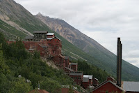
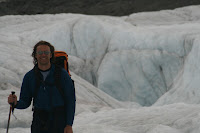
Kennicott is an old mining down that abruptly closed in 1938. It looks like they are trying to restore it into an open-air museum. We hiked past Kennicott and headed towards the Root Glacier. I've seen and been on a number of glaciers over the years, but this one blew my mind. The terminal morraine of this glacier must have covered close to 1000 acres, by my best estimates... it looked like a lunar landscape. We hiked on the side of the valley, and made our way to the toe of the glacier, then hopped up onto it. The section we were on was dirty enough and shallow enough in slope that you didn't need crampons. Gotta love snow-free glaciers. We explored around for a while then once we got as far as we safely could, we headed back off the glacier and back to our campsite. We then packed up and started our drive towards Denali; driving back the dirt road, and stopping at a small campsite for the night.

We treated ourselves with some Alaska King Crab we bought back in Valdez.

Alaska: Where Crab is King

I've only had King Crab a few times in restaurants; it is quite expensive. And I've shied away from experimenting with expensive ingredients. So it was quite the score when we found it here for $10/lb... so no excuses now!!!

Almost everyone, myself included makes crab salad with 'imitation crabmeat', which is really Pollock, a fish. Having tasted real King Crab, I now realize that Pollock is to seafood what Bologna is to deli meat. It's sort of resembles the real thing, but let's not kid ourselves....

It was a totally decadent culinary experience. I thought I had died and gone to heaven. It truly is food of the gods, and tonight we dined with Poseidon.

Thursday, July 19, 2007

Wrangell / St. Elias National Park

So raise your hand if you've heard of Wrangell St. Elias National Park. No? I'm not surprised. But you'd probably be surprised to learn it's the largest of America's national parks. And it's a true wilderness park... there are only two dirt roads into the park. It's kind of like 'going into the ghost' (for all you climbers out there, you know what I mean.... if not, it means a long ride down a poorly maintained dirt road which helps filter out the weeners, allowing only those determined enough to endure the ride. The result: peace and quiet for the dedicated).

Before leaving we backed up the car on seafood: Salmon, Halibut, and King Crab.

So we bid farewell to Valdez and headed up to McCarthy, a small town located within the park. The road is 100km, and takes about 2 hours. The road begins with stunning views of big peaks of the Wrangells: Mt. Sanford, Mt. Drum, and Mt. Wrangell. Interestingly, the first 25km are the worst (i.e. the coarse weener filter). Once there, we explored around. You can't really get to McCarthy by vehicle. We camped at a small campground just before the footbridge which takes you across the Kenicott river to McCarthy. This is the quintessential small-town, and embodies the concept of BFNW. The town population is 67, and the town is comprised of a handful of dirt roads, a hotel, a saloon, two guiding companies and two flightseeing companies.

Tonight we had Copper River Salmon, supposedly the best in Alaska. It lived up to its reputation, this is some of the best salmon we've ever had.

Wednesday, July 18, 2007

A Day of Rest

Even when you're travelling, after a while, it seems like sometimes you need to get away from it all. Today we decided to relax and piss away a day... Did a bit of shopping, had a leisurely lunch, spewed a prolific number of blog entries (gotta love back-dating!), then Carole went for a snooze while I went a checked out the Valdez Museum.

They Museum is actually two buildings, one of which is dedicated to the 'Good Friday Earthquake' of 1964. It measured 9.2 on the Richter scale, one of the largest ever measured in North America (equivalent to 1 million Hiroshima bombs). In some places, shorelines were redefined as some islands sank by 30 feet! Surely a stupendous event, but I did find it a bit odd that the Exxon Valdez oil spill only had one small display in a dank remote corner of the other building.... I'm sure corporate donations go a long ways towards reshaping history these days.

Tonight we made dinner with some fresh Halibut we bought from the local cannery (recommended by Captain Fred no less). The filets were so fresh I swear they were still twitching! There are few things better than seafood when it is fresh.

Tuesday, July 17, 2007

My Belle Lu-Lu

Today we did a boat tour to view the marine life. I've done a number of such boat tours before, in Maine, Newfoundland and California, but this one was over the top. We took a tour with the Lu-Lu Belle, skippered by Captain Fred Rodolf, who as been running this particular tour for 30 years (over 3900 tours so far), and designed the ship he captains.

He's an interesting character with an sardonic sense of humour and an amazing ability to rattle on in an informative and entertaining manner while simultanously steering the boat and scanning the horizon for marine life. He guarantees a minimum tour of 5 hours, and he reserves the right to extend it based on what he finds. We happened to hit the jackpot for marine life; our tour was 8 and a half hours, from 2PM to 10:30. The encountered with whales were never rushed, I think the tourists tired of it before he did, and his attitude was summed up on the way back when he detoured to get close to a Bald Eagle on shore when he commented: "We'll we're so late as it is, we might as well go over and take a look." It's inspiring to see someone who, still doing this after 30 years, is exhibits a such youthful excitement and enthusiasm for his work.

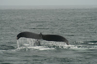
So on our tour we saw Sea Otters, Bald Eagles, Puffins, Orcas (Killer Whales), Sea Lions, Humpback Whales, and Dall Porpoises, and of course, getting as close as we could to the Columbia Glacier. The Orcas seemed somewhat ambivalent to our presence, but one got so close to the boat, if you could reach down it seemed you could almost touch it. The humpbacks were impressive, at one point we got close to three of them travelling together. One of the highlights were the porpoises. Once they noticed the boat, they immediately headed towards it, and like huskies, felt compelled to lead the way. They were crazy, the four of them would stay just ahead of the bow and dart left and right, occasionally doing a roll or surfacing for air. I could not help but laugh the entire time, joining in in their exuberance. Carole sitting beside Captain Fred, said it was like watching people watching a ping-pong tournament, heads racing back and forth following the flurry of action.

Stepping on shore, we decided to dine out and went to a restaurant serving fresh Halibut and Salmon, but by 10:30 we were so ravenous that we hoovered it down without giving it due appreciation.

We both had a hard time falling asleep, our minds still racing with images of all we had seen on this incredible day. We finally solved the problem by counting porpoises.....

Monday, July 16, 2007

Goats and Bears

So this morning, after tending to some errands, we decided to do the Goat trail. An old road before they put in the present highway, it sounded interesting enough, nagivating
the edge of a canyon and with some views of the waterfalls; we were fully expecting some spectacular vistas. Alas, we didn't appreciate how prolific the vegetation is in a coastal rainforest. We spent most of in enshrouded in a canopy of trees with the occasional lookout; when we started having to bushwhack, we decided to cut our losses and turn back. Obviously not as popular as the tourist info centre would have you believe....

Afterwards we went to check out the Vadez Glacier, but could not find a way to get around the terminal lake, otherwise we would have hiked up onto the glacier. It was unusual, because the the toe of the glacier was several km further up the valley beyond, yet the lake was filled with glacial icebergs. Are there any glaciologists out there able to explain why that is?

Later that afternoon we went out and took a drive around the inlet, and saw a salmon run (see below). Driving back, we saw a traffic jam, knowing it was probably wildlife. Normally Carole and I don't stop, since we prefer to see it in a more wild setting rather than by the roadside, but it was a mother bear grizzly and two cubs, so we understandably caved in. I observed the mother for a while, and she seemed very nonchalant about the crowd, barely taking an interest... so out the camera came. She and her cubs were scavenging for food on some tidal flats. We watched them seach for food, and then the two cubs wrestled with each other... it was like something out of National Geographic.

We finally came back to the campground around 8PM and made dinner. Our friendly neighbour, Cheryl, whose son and daughter-in-law was out fishing offered us some freshly caught halibut; it was totally decadent.

Salmon: Getting the Short End of Life's Stick

Note to self: when it's time to be reincarnated, avoid the Salmon option. You only get laid once, and then you die immediately afterwards. And that's assuming you don't get eaten first: you've got to avoid bears, eagles, sea lions, and of course, humans. If there is any cosmic justice out there, one can only hope that this is the fate reserved for murderers, pedophiles, and people who start wars under false pretenses... with any luck, the latter will have a slow lingering evisceration before being chowed down.

Sunday, July 15, 2007

Valdez

So this morning we went for a run. There was a perfectly straight walking path besides the highway. For over 6km, it veered neither left nor right from its intended course. One the one had it was quite boring, but on the other, I realized I never ran a perfectly straight trail, it was interesting to watch the distant mountains grow closer as you ran; running in a loop or circuit you seldom get a sense of the distance you cover.

We then had the campground breakfast - a buffet of pancakes, sausage and fruit; we loaded up on the latter. We were then heading down the highway. It's becoming tiring to try and find superlatives for the views as you drive; today's road was another highlight. After the gently winding road south of Tok, we came upon the Wrangell range. The first glipses were disappointing, you could see the massifs rising from the plains, but the bulk of the mountain was enshrouded in clouds. Eventually, the clouds dissipated a bit, and you could see the peaks towering above the clouds - Mount Sanford at 4949m and Mt. Drum at 3861m. The mind failed to comprehend how massive these peaks are, and the broad sweeping plains before them only seemed to exacerbate their imposing presence.

We continued on, stopping occasionally to take in the views. The final stretch of road into Valdez was another highlight, and we stopped at the Worthington Glacier and hiked to the toe to get close and take a look at it. Continuing on, we came around the corner, and had to pull over again for another spectacular panorama of the valley below, before continuing on.

We finally arrived at Valdez around 6PM - it took us almost 8 hours to cover 400 km due to viewpoints, not road conditions. It is unfortunate that when the average person (who is not an extreme skier) hears of Valdez; the first think that comes to mind is the 1989 oil spill. This place is idyllic, it's like a miniature version of Vancouver: tucked in between mountians and ocean,
but much much smaller. The mountains burst up from the ocean and are carpeted with a lush velvety verdant vegetation, which contrasted with the cloudless blue sky (though were were told this was abnormal - normally, its cloudy and/or foggy). We found a place to stay, had dinner, then went for a walk around this small town before retiring for the night.

Saturday, July 14, 2007

Welcome to Alaska!


Today we drove to from Kluane to Tok (Pronounced 'Toke'), Alaska.

The drive was slow. Within Kluane, we had to wait an hour as the construction crew was widening the road around Kluane Lake. The road that followed was a veritable roller coaster, by far the worst we'd encountered on our travels so far. We had much excitement swerving into the other lane to avoid massive frost heaves. Apparently this was one of the most difficult sections of the Alaska Highway to build (more difficult than through the mountains). The act of constructing the road would disturb the delicate frozen state of the permafrost, which would then start to melt and become a bog. Construction equipment such as bulldozers were apparently swallowed whole during the construction process.

The border itself is at the 141 meridian, and although there is no actual dotted line, the perfectly straight slash through the forest comes quite close. As we were crossing the border, I pondered the irony of the fact the first town after the US border is named 'Toke'. I also pondered the irony that Bear Bangers are considered firearms by US customs. In a country were you can buy a semi-automatic weapon at the corner store, it seemed oddly incongruous. Fireworks maybe, but not firearms. It almost seems they would prefer you shoot the bear, rather than scare it off.

Friday, July 13, 2007

Kluane Park

Kluane: the name evokes images of pristine solitude and mountains shrouded in mist. Well that's certainly the way we found it, along with a good dose of rain.

We arrived here a couple days ago and were hoping to do a hike yesterday, but got rained out.
Today decided to have another go at it. We tried going up to King's throne, which is a classic glacial cirque. A hiking trail would take you up to the cirque, and from there you could scramble the left ridge to the top, where you could get a glimpse of the St. Elias range to the west. We got to the cirque, but everything above was completely socked in. Having become bellweather scramblers over the years, the lack of even the possibility of a view totally killed our motivation, so we headed back down and started hitting the Hootch earlier than usual.

We have been told by the locals that the weather this year has been unusual; being in the rain-shadow of the St. Elias and Kluane ranges, the climate is normally arid for this lattitude. This has been one of the wettest summers they can remember. Lucky us; we decided to pack it in and continue on to Alaska.

Thursday, July 12, 2007

Hootch: A Yukon Icon


I'm sure most people have heard about having a swig of the ol' Hootch. I had just assumed that this was some colloquial slang for alcohol. However, in Whitehorse I found out that "Hootch" is an actual product whose name, over time, has become synonymous with alcohol. (like Kleenex and Ski-Doo are synonymous with tissue paper and snowmobiles, respectively).

Like the Newfie Screetch, it is basically has become an icon of the local culture. Many thanks to Stephanie for her generous gift!

Cheers!

Wednesday, July 11, 2007

Our Expenses So Far

Up until the Chilkoot trail, our primary expenses so far, in descending order are:

1) Gas
2) Food
3) Alcohol
4) Accommodation

I'm not sure if the fact that alcohol precedes accommodation is a good thing or not. Let you think us prolific alcoholics, please keep in mind that accommodations means camping fees, which is not the same magnitude as a room at the Hilton.

It will be interesting once we get to Alaska whether the cheaper gas bumps alcohol into the #2 position. Oh well, the priorities on this trip are becoming clear.....

Tuesday, July 10, 2007

The Chilkoot Trail

The Chilkoot Trail was the route used by the gold seeking 'Stampeders' during the 1897/8 Klondike gold rush, taking them from the port town of Dyea (near Skagway, where they arrived by ship), up and over the Chilkoot Pass, and down the other side to Lake Bennett. There, they would continue on via boats down the lakes and river systems to Dawson City and the gold fields.

One of the most iconic photographs of the 1898 trail was the human chain of Stampeders slowly making their way up the 'Golden Staircase', a steep 45 degree slope which would take them over the Chilkoot Pass. The photo seems to exemplify both the hardships and mania of the endeavour.

Having just completed the route, that photo only gives a glimpse of the undertaking. We did the 53 km trail in 5 days in summer conditions and with modern gear. It would take them about three months to complete the route in the dead of winter, because they had to do the trip not once, not five times, but 30 to 40 times on average. The Canadian Mounties, sensing a potential famine in the making, required all Stampeders to bring a 'ton of goods' with them when entering Canada, construing a year's worth of supplies.


One of the most striking aspect of the trail for us was the diversity of ecosystems; the first two days we spent hiking through Coastal rainforest, then made our way into the alpine as we went over the pass, and descended into Boreal forest. There was packed snow on the Golden Staircase, giving any mis-step serious consequences, as you would slide down accelerating into the rocks below, as some unfortunate hiker had done two weeks prior.

Once over the pass, the views descending towards the pristine landscape of Crater Lake were spectacular, and it was easy to imagine this was what the world looked like a billion years ago. Arriving at Lake Bennett on the final day, we then boarded a train which would take us back to Skagway, where pizza and cold beer awaited us.